Back Igboland Catalan Igboland English Igboland French Kasar Inyamurai Hausa Igboland IG Igboland Dutch Ibolândia Portuguese Igboland Romanian

| Igbolando | ||
|---|---|---|
| Kultura kaj komunlingva regiono | ||
 | ||
| regiono [+] | ||
| Lando | Niĝerio | |
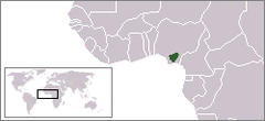
| - koordinatoj | 6° 27′ 10″ N, 7° 30′ 37″ O (mapo)6.45266666666677.5103333333333Koordinatoj: 6° 27′ 10″ N, 7° 30′ 37″ O (mapo) | |
| Akvokolektejo | 40 000 km² (4 000 000 ha) [+] | |
| Areo | 40 000 km² (4 000 000 ha) [+] | |
| Loĝantaro | 40 000 000 [+] (2016) | |
| Denseco | 1 000 loĝ./km² [+] [+] | |
 |
||
| Igbolando | ||
| En TTT: Oficiala retejo [+] | ||

Igbolando (igbe Àlà Ị̀gbò),[1][2] ankaŭ konata kiel Sudorienta Niĝerio, estas la indiĝena hejmregiono de la igboj.[3][4] Ĝi estas kultura kaj komunlingva regiono en suda Niĝerio. Ĝi dividiĝas geografie per la Niĝero.[3] La loĝantaro enhavas diversan igban kulturon kaj la same diversajn igbajn lingvojn.[3][5][6]:307[6]:315
Igbolando dividiĝas je pluraj sudaj niĝeriaj ŝtatoj. Ĝi dividiĝas kulture je pluraj subgrupoj, inkluzive la jenaj etnoj:
- Anioma
- Ngwa
- Aro
- Ezza
- Ibeku
- Ohuhu
- Ikwere
- Ogba/Egbema
- Omuma
- Ohafia
- Oyigbo
- Mbaise
- Ekpeye
- ↑ https://businessday.ng/columnist/article/planting-and-watering-the-grass-of-ala-igbo-for-a-new-era/
- ↑ https://www.legit.ng/1151109-origin-igbo-tribe-nigeria.html
- ↑ 3,0 3,1 3,2 The Igbo People - Origins & History. www.faculty.ucr.edu. School of English, Queen's University of Belfast. Alirita April 20, 2016.
- ↑ Baikie (1854) uses I´gbo as the term for Igboland: "I´gbo, as I have formerly mentioned, extends east and west, from the Old Kalabár river to the banks of the Kwóra, and possesses also some territory at Abó to the westward of the latter stream." (p. 307).
- ↑ Chigere, Nkem Hyginus. (2000) Foreign Missionary Background and Indigenous Evangelization in Igboland: Igboland and The Igbo People of Nigeria. Transaction Publishers, USA. ISBN 3-8258-4964-3.
- ↑ 6,0 6,1 Narrative of an Exploring Voyage up the rivers of Kwora and Binue (commonly known as Niger and Tsádda) in 1854 with a map and appendices. ia600303.us.archive.org. John Mueray, Albemarle Street (published with a sanction of Her Majesty's Government). (1856). Alirita April 24, 2016.
© MMXXIII Rich X Search. We shall prevail. All rights reserved. Rich X Search


